Juneau’s annual glacial outburst flood started Tuesday morning and is expected to peak Wednesday afternoon. Experts predict it could be the largest flood on record.
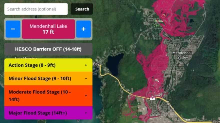
This year, the flood will test a temporary levee installed by the city in the spring. But not every street in the flood zone is protected by the barrier.
On Tuesday, as floodwaters rose, the City and Borough of Juneau issued an evacuation advisory. Some residents heeded the warning, but others hunkered down at home. Everyone waited to see whether preparations made over the past year would protect their homes from a third catastrophic flood.
Malachi Thorington and Elizabeth Figus were among the residents who evacuated. They packed their blue Chevy truck Tuesday to stay at a friend’s house, as the sound of the rising Mendenhall River rushed behind their home.
The first floor of their house flooded the past two years. Thorington said he knows the drill now.
“Just kind of dealing with the present, at the moment, basically going into damage mitigation mode. Try not to feel anything, just try to go as mechanical as possible,” he said. “There will be things that are lost, and I really hope that other people have taken this seriously.”

At the end of View Drive, a colossal man-made berm separates Carol and Don Habeger’s house from the cold rushing water.
Walking along the berm Tuesday, they watched a young spruce on the other side of the river crash into the torrent. Along with a couple of neighbors, the Habegers spent the past month erecting the levee around their home of more than 20 years. The city constructed a separate temporary levee farther downriver.
“We are trying to save our property — we are trying to save our equity,” Habeger said.
The couple plans to stay home, even as the river is projected to reach a record-breaking level of 16.6 feet.
“I was going to invite folks, but I don’t want the liability,” he said.

At a press briefing Tuesday morning, Warning Coordination Meteorologist for the National Weather Service Nicole Ferrin said the river was already unusually high because of rain from the past few days.
“This will be a new record based on all of the information that we have,” she said.
The city is encouraging residents to evacuate the area, but it’s not a mandatory order. On Monday, the city hung nearly 900 informational door flyers in Mendenhall Valley neighborhoods in the flood zone and launched a flood information hotline.
Residents can see whether their home is in the flood zone by visiting Juneauflood.com. Though city officials say they’re confident the barriers will hold, they don’t want people to test it with their lives. The area includes homes along the river, down Riverside Drive to Safeway, past Glacier Highway and near the Juneau International Airport.

Capital City Fire/Rescue Assistant Chief Sam Russell said emergency responses will become more difficult as the river rises. He asked residents to stay away from the river and bridges as much as possible.
“As the flood goes up, our ability to navigate the waters goes down due to the debris that flows down through it makes navigating the river with a boat very, very difficult,” he said.
At the Floyd Dryden campus, the American Red Cross is prepared to receive people who follow the evacuation advisory.

Michael Downs is the Juneau district ranger for Tongass National Forest. He closed down the Forest Service campground on Mendenhall Lake Tuesday morning.
He said the Forest Service is also managing disaster tourism in the area – people wanting to get an in-person glimpse of the flooding. He said all lakeside trails and roads by the Visitor Center and near Skater’s Cabin are closed. Anyone who violates that could face consequences.
“This year, we just did a forced order that they can be fined up to like, $5,000 so [it’s] got a little bit more teeth this year,” he said.
He said on top of being a safety concern, it’s to protect the employees.
“Their homes are impacted, and they work there, and people are oohing and ahhing about their disaster and it’s yucky,” he said. “I prefer people don’t come in there.”
Floodwaters are expected to peak Wednesday afternoon, and then drop through Thursday morning.

