Avalanches blocked a highway on the Kenai Peninsula and killed a skier near Matanuska Glacier within the last week. There were also several avalanches reported around Juneau, including a very close call just outside the boundaries of the Eaglecrest Ski Area.
There may be high potential for human-triggered avalanches over the next few weeks, even inside the ski area.
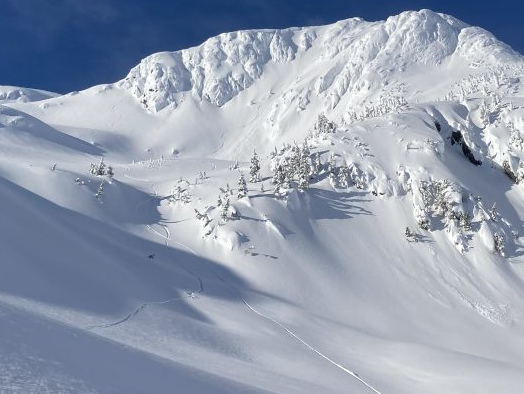
Skier Devon Calvin said he watched another skier trigger an avalanche on Mt. Ben Stewart on Douglas Island last Sunday. He recounted his experience on the Coastal Alaska Avalanche Center website and included a video that was also posted to YouTube.
Calvin had skied down earlier on that sunny day. An hour later, he was watching three other skiers come down the same path when one triggered an avalanche estimated at 150 feet wide. It ran for at least 500 feet.
Calvin watched as the third skier appeared to hold his own and not get carried down the slope. But in what is probably an understatement, Calvin ended his report by writing: “I’m a little rattled.”
The Coastal Alaska Avalanche Center said they saw evidence of at least four different avalanches off Mt. Ben Stewart on Sunday morning.
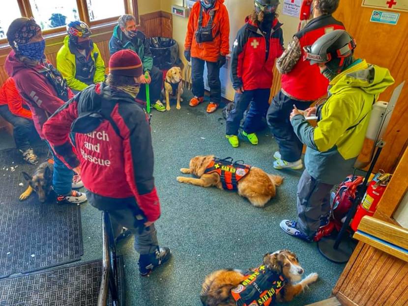
SEADOGS, or Southeast Alaska Dogs Organized for Ground Search, said they planned on doing training exercises at Eaglecrest Ski Area on Sunday. But because of what happened, they paused their training to stand by, in case they had to quickly get to an avalanche scene and do a real rescue.
Tom Mattice, the city’s urban avalanche forecaster and emergency programs manager, said there was “considerable” avalanche danger on that day, on top of the past several days.
“And people get kind of complacent, and then the sun comes out and it’s, ‘Today’s my day. I’m going to go up there!’” said Mattice. “Considerable danger is not low danger, and it’s not no danger. It just means that natural avalanches are less likely.”
Human-triggered avalanches are still very likely: Mattice said most fatalities actually occur at the ‘considerable’ danger level.
In other reports posted to the Coastal Alaska Avalanche Center website on Saturday, one person reported a fellow skier getting caught in a small slide at nearby Fish Creek Knob. Another reported turning around and going back after digging a snow pit and finding unstable snowpack in the same area.
Dave Scanlan, Eaglecrest Ski Area general manager, said their ski patrol does avalanche mitigation every morning before they open to the public, ranging from ski cuts to release thin snow layers to dropping explosive charges. But that’s only within the ski area.
Scanlan said they can’t control what anyone does outside their boundaries.
“A lot of the backcountry ski enthusiasts will come up to the parking lot and they’ll leave the parking lot and hike up towards Mt. Ben Stewart or Mt. Troy, both on neighboring state lands,” Scanlan said.
Scanlan also worries about people coming up when the ski area is closed and the ski patrol hasn’t had a chance to go out after a big snowfall.
“It’s easy to get complacent and not realize the hazards that exist just within the average ski area boundaries,” Scanlan said. “So, when people are hiking up the slopes on our closed days, the risk for avalanches is still very much present.”
Last weekend, Mattice said avalanche control measures on Gastineau Peak brought down enough to cover Thane Road with snow 15 feet deep and 100 feet wide.
There were also small slides at the bottom of the Behrends Avenue avalanche path, but no activity higher up on Mt. Juneau.
“This is the warmest period we’ve had in quite some time with the temperatures as well as having more than an inch of rain each day or right at an inch of rain each day,” Mattice said. “So, we’re seeing a lot of loading during a warm period with significant wind and we’re back to high danger.”
The urban avalanche danger was lowered back down to “considerable” level on Thursday. But Mattice said the snow layer featuring the deep persistent slab from last month likely still exists throughout the region.
Matt Miller is a reporter at KTOO in Juneau.


